Портал:Африка
 | Статус обслуживания портала: (апрель 2019 г.)
|


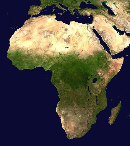
Африка является вторым по величине и вторым по численности населения континентом в мирепосле Азии . Около 30,3 млн км 2 (11,7 млн квадратных миль) включая прилегающие острова, она охватывает 20% площади суши Земли и 6% от ее общей площади поверхности. С почти 1,4 миллиарда человек по состоянию на 2021 год, она составляет около 18% от населения мира. Население Африки является самым молодым среди всех континентов; медианный возраст в 2012 году составлял 19,7 лет, когда медианный возраст в мире составлял 30,4 года. Согласно прогнозам на 2024 год, население Африки достигнет 3,8 миллиарда человек к 2099 году. Несмотря на широкий спектр природных ресурсов , Африка является наименее богатым континентом на душу населения и вторым наименее богатым по общему богатству, опережая Океанию . Ученые приписывают это различным факторам, включая географию , климат , коррупцию , колониализм , холодную войну и неоколониализм . Несмотря на эту низкую концентрацию богатства, недавний экономический рост и большое и молодое население делают Африку важным экономическим рынком в более широком глобальном контексте. Африка обладает большим количеством природных ресурсов и продовольственных ресурсов, включая алмазы , сахар , соль , золото , железо , кобальт , уран , медь , бокситы , серебро , нефть , природный газ , какао-бобы и.
Африка расположена по обе стороны экватора и нулевого меридиана . Это единственный континент, простирающийся от северного умеренного до южного умеренного пояса. Большая часть континента и его стран находятся в Северном полушарии , а значительная часть и ряд стран — в Южном полушарии . Большая часть континента лежит в тропиках, за исключением большой части Западной Сахары , Алжира , Ливии и Египта , северной оконечности Мавритании и всех территорий Марокко , Сеуты , Мелильи и Туниса , которые, в свою очередь, расположены выше тропика Рака , в северном умеренном поясе . На другом конце континента, южная Намибия , южная Ботсвана , большие части Южной Африки , все территории Лесото и Эсватини и южные оконечности Мозамбика и Мадагаскара расположены ниже тропика Козерога , в южном умеренном поясе .
Африка отличается высоким биологическим разнообразием ; это континент с наибольшим количеством видов мегафауны , поскольку он меньше всего пострадал от вымирания мегафауны плейстоцена . Однако Африка также сильно страдает от широкого спектра экологических проблем , включая опустынивание, вырубку лесов, нехватку воды и загрязнение . Ожидается, что эти укоренившиеся экологические проблемы будут ухудшаться по мере того, как изменение климата влияет на Африку . Межправительственная группа экспертов ООН по изменению климата определила Африку как континент, наиболее уязвимый к изменению климата .
История Африки длинная, сложная и разнообразная, и часто недооценивалась мировым историческим сообществом . В африканских обществах устное слово почитается , что привело антропологов к тому, чтобы называть их устными цивилизациями, а не письменными цивилизациями . Исторический процесс в значительной степени является коллективным , с рассказами очевидцев, слухами , воспоминаниями и иногда видениями , снами и галлюцинациями, оформленными в устные традиции . Время иногда мифично и социально, а истина обычно рассматривается как релятивистская . Отсутствие всеобъемлющих письменных записей означало, что африканская историография в значительной степени была задумана чужаками ( европейцами и арабами ), которым по-прежнему было поручено создание институциональных рамок, включение африканских эпистемологий и представление африканской перспективы.. ( Полная статья... )
Избранная статья –
Наскальное искусство Сабу -Джадди в Судане представляет собой уникальное скопление из более чем 1600 наскальных рисунков разных исторических периодов, охватывающих более 6000 лет различных эпох нубийской цивилизации. Однако точное время, когда люди, живущие в этом регионе, начали создавать эти изображения, до сих пор неизвестно. Место расположено в 600 км к северу от Хартума между деревнями Сабу и Джадди. На хорошо сохранившихся рисунках изображены дикие и домашние животные, люди и лодки.
В связи со строительством электростанции «Каджбар» это место было включено в Список всемирного наследия ЮНЕСКО 2016 года , в который входят находящиеся под угрозой исчезновения памятники, требующие внимания, продвижения и защиты. ( Полная статья... )
Избранные фотографии –
Вы знали(сгенерировано автоматически)-

- ... что Мухсин Хендрикс из Южной Африки был назван «первым в мире открытым геем- имамом »?
- ... что Мэри Джейн Паттерсон , чья мать была афроамериканской рабыней, получила степень бакалавра в 1862 году, прослушав «курс для джентльменов»?
- ... что «Anglo-African» была первой газетой, издававшейся в британской колонии Лагос ?
- ... что в Африке криминализация гомосексуализма была колониальным навязыванием, а декриминализация гомосексуализма встречает сопротивление как неоколониальное навязывание?
- ... что перед принятием присяги осужденным за убийство Кенни Мотсамаи в качестве депутата парламента главный судья ЮАР Могоенг Могоенг сослался на конституционное требование, запрещающее преступникам становиться депутатами парламента?
- ... что гольф -клуб Shady Rest Golf and Country Club был домом Джона Шиппена , первого афроамериканца, участвовавшего в Открытом чемпионате США ?
Категории
Избранная биография –
Уильям Генри Шеппард (8 марта 1865 г. – 25 ноября 1927 г.) был одним из первых афроамериканцев, ставших миссионерами пресвитерианской церкви . Он провел 20 лет в Африке, в основном в Свободном государстве Конго и вокруг него, и наиболее известен своими усилиями по преданию огласке зверств, совершенных против куба и других конголезских народов Force Publique короля Леопольда II .
Усилия Шеппарда внесли вклад в современную дискуссию о европейском колониализме и империализме в регионе, особенно среди афроамериканского сообщества. Однако было отмечено, что традиционно ему уделялось мало внимания в литературе по этой теме. ( Полная статья... )
Выбранная страна –
 |  | ||
 | |||
Уганда , официально Республика Уганда , —страна в Восточной Африке , не имеющая выхода к морю , граничащая на востоке с Кенией , на севере с Суданом , на западе с Демократической Республикой Конго , на юго-западе с Руандой и на юге с Танзанией . Южная часть страны включает в себя значительную часть озера Виктория , в пределах которого она граничит с Кенией и Танзанией. Страна расположена на Восточно-Африканском плато , в среднем на высоте около 900 метров (2950 футов) над уровнем моря. Уганда получила свое название от королевства Буганда , которое охватывает часть юга страны, включая столицу Кампалу .
Президент Уганды , в настоящее время Йовери Мусевени , является как главой государства , так и главой правительства. Президент назначает премьер-министра , который помогает ему в выполнении его задач. Действующий премьер-министр - Аполо Нсибамби . Парламент формируется Национальной ассамблеей , которая насчитывает 303 члена. Восемьдесят шесть из этих членов назначаются группами интересов, включая женщин и армию . Остальные члены избираются на пятилетний срок во время всеобщих выборов . ( Подробнее... )
Выбранный город –
Конакри ( / ˈ k ɒ n ə k r i / KON -ə -kree , французский: [kɔnakʁi] ; Сусу : Кɔнакири ; Н'Ко : ➀ , латинизированный: Kɔnakrí ; Фула : 𞤑𞤮𞤲𞤢𞥄𞤳 𞤭𞤪𞤭 , латинизировано: Конаакири ) — столица и Крупнейший город Гвинеи . Портовый город, он служит экономическим, финансовым и культурным центром Гвинеи. Его население по данным переписи населения Гвинеи 2014 года составляло 1 660 973 человека.
Текущую численность населения Конакри трудно определить, хотя Бюро по делам Африки Госдепартамента США оценило ее в два миллиона человек, что составляет одну шестую часть всего населения страны. ( Полная статья... )
В новостях
- 12 февраля 2024 г. –
- Два судна столкнулись на реке Конго недалеко от Киншасы , Демократическая Республика Конго ; число погибших остается неизвестным. (AP)
- 11 февраля 2024 г. – Кубок африканских наций 2023 г.
- В футбольном сообществе хозяева Кот-д'Ивуара выигрывают свой третий Кубок африканских наций , обыграв Нигерию со счетом 2–1 в финале . Себастьен Аллер забивает победный гол на 81-й минуте. (The Guardian)
- 10 февраля 2024 г. – Гражданская война в Сомали
- Четыре эмиратских солдата и бахрейнский военный офицер погибли, а еще десять человек получили ранения, когда солдат открыл огонь на военной базе в Могадишо , Сомали , прежде чем был убит в последовавшей перестрелке . Ответственность за это берет на себя группировка «Аш-Шабааб» . (AP)
- 10 февраля 2024 г. –
- Вертолет Eurocopter EC130 потерпел крушение недалеко от Ниптона , Калифорния , США , в результате чего погибли все шесть человек, находившихся на борту, включая нигерийского банкира Герберта Вигве . (CBS News)
- 10 февраля 2024 г. – протесты в Сенегале 2023–2024 гг.
- В Сенегале произошли жестокие протесты после заявления президента Маки Салла о переносе президентских выборов с 25 февраля на 15 декабря. (Sky News)
- 9 февраля 2024 г. –
- По меньшей мере 18 человек погибли в результате столкновения автобуса и грузовика на дороге в Киншасе , Демократическая Республика Конго . (AP)
Обновлено: 16:33, 14 февраля 2024 г.
Общие изображения -
Африка темы
Знаете ли вы больше –
- ... что Либерийский колледж в стране Либерия был учрежден законодательным органом в 1851 году, но занятия в нем начались только в 1863 году?
- ... что принудительное выселение 700 000 человек из трущоб в Зимбабве в 2005 году было названо ООН « преступлением против человечности » ?
- ... что верховным богом южноафриканских бушменов является Кагн , обманщик , который принимает облик богомола ?
- ... что вера бахаи в Нигере зародилась в период широкомасштабного роста этой религии в странах Африки к югу от Сахары ближе к концу колониального периода ?
Связанные порталы
Основные религии Африки
Северная Африка
Западная Африка
Центральная Африка
Восточная Африка
Южная Африка
Ассоциированный Викимедиа
Более подробную информацию по этой теме можно найти в следующих родственных проектах Фонда Викимедиа :
Бесплатный репозиторий Commons- Wikibooks
Бесплатные учебники и руководства - Wikidata
Бесплатная база знаний - Wikinews
Новости свободного контента - Wikiquote
Коллекция цитат - Wikisource
Библиотека свободного контента - Wikispecies
Справочник видов - Wikiversity
Бесплатные инструменты обучения - Wikivoyage
Бесплатный путеводитель - Викисловарь
и тезаурус


_adult_male.jpg/440px-Sable_antelope_(Hippotragus_niger)_adult_male.jpg)
.jpg/440px-Africa_(satellite_image).jpg)


.jpg/440px-GEA-32-Deutsch_Ostafrikanische_Bank-5_Rupien_(1915).jpg)
.jpg/440px-SWA-15a-Swakopmunder_Buchhandlung-Two_Mark_(1916).jpg)


.jpg/440px-Roan_antelope_(Hippotragus_equinus_koba).jpg)


.jpg/440px-Lucy_(Frankfurt_am_Main).jpg)


.jpg/440px-Pre-Neolithic_and_Neolithic_migration_events_in_Africa_(excluding_Basal-West-Eurasian_geneflow_during_the_Paleolithic).jpg)
.jpg/440px-Brooklyn_Museum_L54.5_Fragment_of_a_Head_(3).jpg)


