Район Клонг Той
This article needs additional citations for verification. (April 2021) |
Клонг Тоей คลองเตย | |
|---|---|
 Вид на Клонг Той от перекрестка Асок в сторону Наны | |
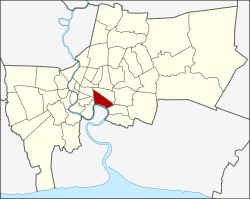
 Расположение Khet в Бангкоке | |
| Координаты: 13°42′29″N 100°35′2″E / 13.70806°N 100.58389°E / 13.70806; 100.58389 | |
| Страна | Таиланд |
| Провинция | Бангкок |
| Сиденье | Клонг Тоей |
| Кхвенг | 3 |
| Кхет установил | 9 ноября 1989 г. |
| Область | |
• Общий | 13,0 км 2 (5,0 кв. миль) |
| Население (2017) | |
• Общий | 102,945 [1] |
| • Плотность | 7,918.84/км 2 (20,509.7/кв. миль) |
| Часовой пояс | UTC+7 ( ICT ) |
| Почтовый индекс | 10110 , за исключением частей Пхра Кханонг: 10260 |
| Геокодировать | 1033 |
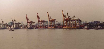
Khlong Toei (также Klong Toey , тайский : คลองเตย , произносится [kʰlɔ̄ːŋ tɤ̄ːj] ) — район в центре Бангкока , давно известный своими трущобами . Он граничит с рекой Чао Прайя и содержит крупные портовые сооружения. Здесь также находится крупный рынок — рынок Khlong Toei .
Соседние районы (по часовой стрелке с севера): Ваттхана , Пхра Кханонг , район Пхра Прадаенг провинции Самут Пракан (через Чао Прайя ), Ян Нава , Сатон и Патум Ван .
История

История этого района восходит к девятому веку как порт для городов, расположенных вверх по течению реки Чао Прайя , таких как Пак Нам Прадаенг (тайский: เมืองปากน้ำพระประแดง) (в отличие от нынешнего Пхра). Район Прадаенг ), построенный в период правления короля Пхуттайотфа Чулалока .
Khlong Thanon Trong (тайский: คลองถนนตรง) был khlong (каналом) и параллельной дорогой, построенной королем Монгкутом около 1857 года. Позже разные участки канала стали известны как Khlong Toei и Khlong Hua Lamphong. Khlong Toei означает «канал пандана », так как растение росло вдоль южного берега канала. Дорога была переименована в Rama IV Road королем Ваджиравудхом в 1919 году. В 1947 году большая часть канала Khlong Toei была засыпана, чтобы расширить поверхность Rama IV Road.
Район когда-то был частью округа Пхра Кханонг , но 9 ноября 1989 года он был отделен, чтобы сформировать новый округ Кхлонг Тоей. Первоначально Кхлонг Тоей состоял из шести подокруга, три из которых позже образовали новый округ Ваттхана (объявлено 14 октября 1997 года, вступило в силу 6 марта 1998 года).
The squatted informal settlement was surveyed in 1971 and is one of the largest slums in Bangkok. In 2006, it was estimated that between 80,000 and 100,000 people live there.[2][3]
Administration

The district is divided into three subdistricts (khwaeng). From west to east, these are:
| 1. | Khlong Toei | คลองเตย | from the railway to Soi Sukhumvit 22 |
| 2. | Khlong Tan | คลองตัน | from Soi Sukhumvit 22 to Soi Sukhumvit 36 |
| 3. | Phra Khanong | พระโขนง | from Soi Sukhumvit 36 to Soi Sukhumvit 52 |
Khlong Toei is both the name of a subdistrict and the district in which it lies. Phra Khanong is both a subdistrict of Khlong Toei and a district on its own, with only subdistrict Bang Chak. Furthermore, all three subdistricts listed above have counterparts with the addition of "nuea" (north) in Watthana District.
Port
Khlong Toei Port, also known as Bangkok Port, was formerly Thailand's only major port for sea transportation of cargo. Its construction began in 1938 and finished after World War II. The port is on the Chao Phraya River, not far from the Gulf of Thailand. Due to its limited capacity and traffic problems caused by semi-trailer trucks, many of its operations have moved to Laem Chabang Port in Chonburi province since its opening in July 1981.
Places of interest


- Bangkok Planetarium
- Science Center for Education
- Tamnak Plai Noen, the historic residence of Prince Naris, now converted into a small museum.
- The Emporium, a luxury shopping center.
- Nana Plaza, a major adult entertainment center, known for prostitution and go-go and hostess bars.
- Queen Sirikit National Convention Center, served by the MRT station of the same name, hosts various exhibitions around the year. The venue will be closed for renovation following contract extension.[4]
- Benjakitti Park, a public park next to the convention center. It includes a lake and is on land that was formerly occupied by the Tobacco Monopoly, the government's tobacco factory.
- Benjasiri Park, a public park created to commemorate Her Majesty Queen Sirikit's 60th birthday. It is next to the Emporium.
- Chuvit Garden, a public park in the district created by massage parlor tycoon-turned-politician Chuwit Kamolvisit from his own plot of land, about 2,400 m2 (26,000 sq ft) in size and worth about 1,250 million baht at the time of opening.[5] Opened in December 2005, it is on Sukhumvit Soi 10.
- Khlong Toei Market, Bangkok's largest wet market.
- The Khlong Toei slum, south of the expressway and north of the port, is the largest and oldest slum of Bangkok. It houses some 100,000 people on about one square mile (260 ha) of land owned by the Port Authority.[6]
- Metropolitan Electricity Authority
- The Customs Department
- PAT Stadium off Sunthon Kosa Road.
- Port Authority of Thailand and Bangkok Port
- Eastern Bus Terminal (Ekkamai)
- Tobacco Authority of Thailand (Formerly known as Thailand Tobacco Monopoly)
The following places of interest were formerly in Khlong Toei District:
- Lumpinee Boxing Stadium, an indoor Muay Thai arena, now moved to Ram Intra Road, Bang Khen District.
- Suan Lum Night Bazaar, closed due to contract expiry, now moved to Suan Lum Night Bazaar Ratchadaphisek.
- Stock Exchange of Thailand Building. Now the office is moved to Din Daeng district.
Diplomatic missions
- Embassy of Chile[7]
- Embassy of Cuba[7]
- Embassy of the Philippines[7]
- Embassy of Romania[7]
- Embassy of Spain[7]
- Embassy of Sudan[7]
Transportation
- BTS skytrain (BTS) stations in the district include Nana, Asok (with interchange to MRT Sukhumvit station), Phrom Phong, Thong Lo, Ekkamai, Phra Khanong, and On Nut, respectively, all of which are located along Sukhumvit Road on the BTS Sukhumvit Line.
- MRT (MRTA) has stations Khlong Toei, Queen Sirikit National Convention Center and Sukhumvit (interchange to BTS).
- Eastern Bus Terminal (also called Ekkamai Bus Terminal) has intercity buses to destinations such as Pattaya, Rayong and Trat. It is on Sukhumvit Road, near the Ekkamai BTS station.
Economy
![[icon]](http://upload.wikimedia.org/wikipedia/commons/thumb/1/1c/Wiki_letter_w_cropped.svg/20px-Wiki_letter_w_cropped.svg.png) | This section needs expansion. You can help by adding to it. (March 2017) |
- The head office of Asia Atlantic Airlines is on the 11th floor of the Times Square Building in Khlong Toei District.
- The State Railway of Thailand (SRT) is a large landowner in Thailand. Its latest property development scheme is the Chao Phraya Gateway project, a mix of hotels, shopping centers, and condominiums.[8] It capitalizes on SRT's 277 rai, 1.16 kilometer-long stretch of land on the river in the Khlong Toei District. The SRT hopes the project will help clear its 100 billion baht debt. The project is projected to break even within eight years and deliver profits of 140 billion baht. As of April 2019[update], SRT's plans are being submitted to the Transport Ministry for approval.[9]
Education
![[icon]](http://upload.wikimedia.org/wikipedia/commons/thumb/1/1c/Wiki_letter_w_cropped.svg/20px-Wiki_letter_w_cropped.svg.png) | This section needs expansion. You can help by adding to it. (March 2013) |
The Sacred Heart Convent School is in Khlong Toei.
References
- ^ "Population and House Report for Year 2017 (see page 2 for data of this district)". Department of Provincial Administration, Ministry of Internal Affairs. Retrieved 2018-04-01. (Search page)
- ^ PORNCHOKCHAI, SOPON. City Report Bangkok (PDF). HABITAT.
- ^ Swift, Richard (2 January 2006). "The lease on life". New Internationalist. Retrieved 13 April 2021.
- ^ "QSNCC event holders seek new homes". Bangkok Post. 2 April 2018. Retrieved 2019-04-17.
- ^ "Chuwit opened billion Baht value garden, asking other billionaires to do the Same". Manager (in Thai). 24 December 2005. Archived from the original on 12 March 2007. Retrieved 11 December 2015.
- ^ Sapsuan, Peewara (2014-04-28). "Bangkok's Klong Toey Slum". BORGEN. Retrieved 2017-11-06.
- ^ a b c d e f "Diplomatic and Consular List" (PDF). Retrieved 16 August 2019.
- ^ Ruiz, Todd; Kamolvattanavith, Teirra (31 December 2019). "Khlong Toei Rising: Anxiety and unity in Bangkok's biggest slum". Coconuts Bangkok. Retrieved 1 January 2020.
- ^ Hongtong, Thodsapol (2019-04-16). "SRT eyes new city river icon". Bangkok Post. Retrieved 2019-04-17.
External links
- BMA website with the tourist landmarks of Khlong Toei
- Khlong Toei district office (Thai only)
- History of Khlong Toei port[dead link]

